Overland Flooding?
Overland Flooding is when the water has not made it to a creek or river and is just barreling across the landscape.
As part of a mandated NSW-wide policy (NSW Flood Prone Land Policy) requiring all councils to help reduce the impact of flooding on communities, Hornsby Shire Council has prepared a Draft Flood Risk Management Study & Plan (FRMS&P).
This draft is based on an extensive engineering study and has undergone an independent peer review.
This Plan will assist us to:
The Draft Flood Risk Management Study and Plan (FRMS&P) sets out a strategic approach to managing flood risks across the Hornsby Shire. Accurate flood modelling is essential for effective land use planning and emergency response.
In response to community concerns, an independent Peer Review was carried out in 2024.
The independent peer review has confirmed the accuracy of the data and modelling of the Draft 2023 FRMS&P.
Council first commissioned a Flood Risk Management Study and Plan in 2014, in line with the NSW Flood Prone Land Policy.
In 2023, Council sought feedback on the draft FRMS&P Community Consultation 2023.
Overland Flooding is when the water has not made it to a creek or river and is just barreling across the landscape.
Annual Exceedance Probability (AEP)) flood event means there is a chance of a flood event of a certain size or larger happening in any one year. For example, a 1% AEP means there's a 1 in 100 chance it could occur in any given year.
This is the largest flood that could conceivably occur at a particular location ever. It’s estimated based on the most extreme rainfall combined with the worst possible conditions for flooding in that area.
Riverine Flooding is when regular water courses like creeks and rivers rise and even break their banks.
Please check for your property on the map below and read the additional information on Key Issues
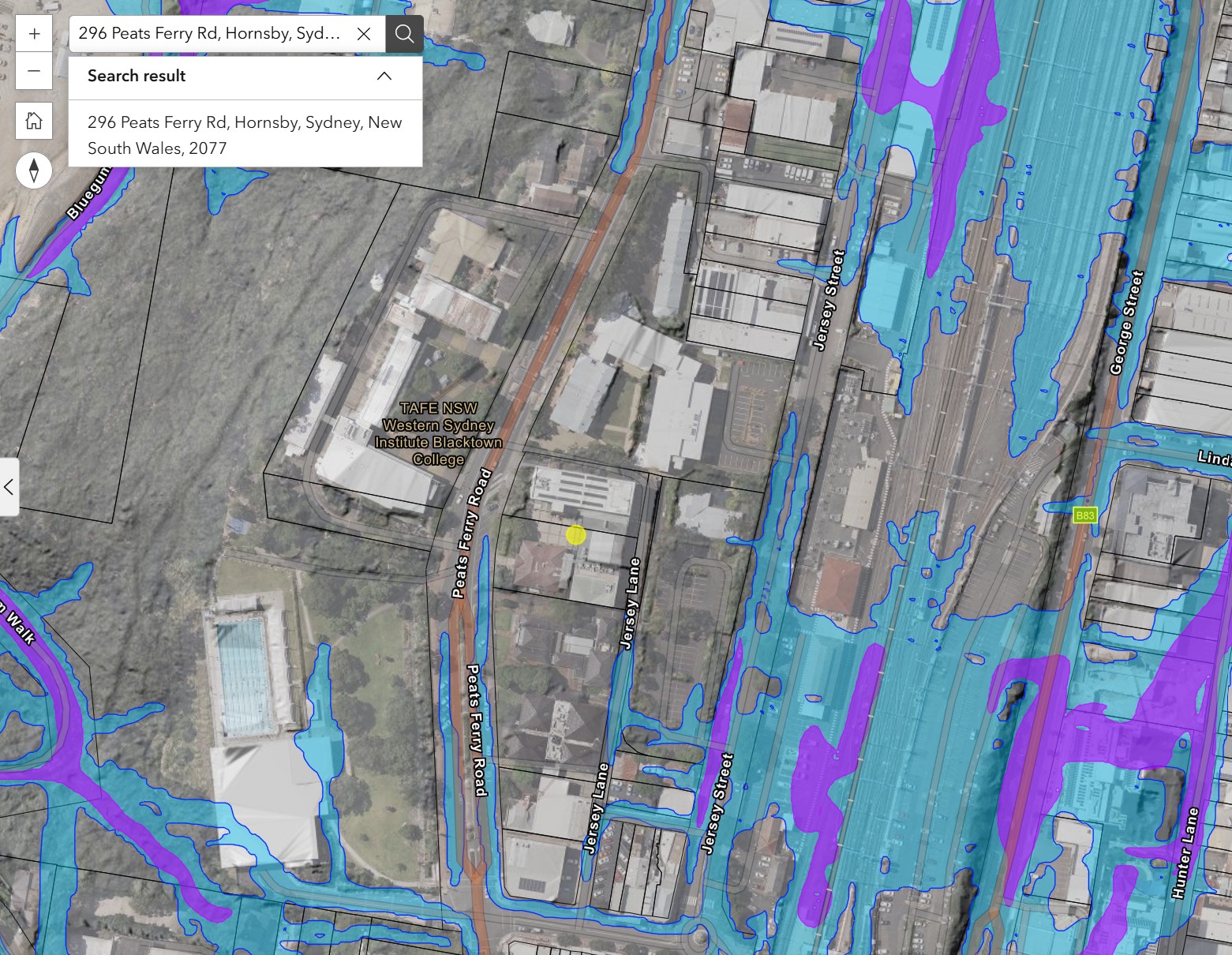
Flood Risk Management Study HSC Flooding
1. Click the link here
2. Type the correct address in the address box
3. Impacted properties will show a blue or purple colour.
Purple = affected by 1% AEP
Blue = affected by PMF
Theme number 9 - 20
A property is defined by its surveyed boundaries. The land within these boundaries is called a “lot.” If any part of a lot is in a Flood Planning Area, the whole lot is called a Flood Control Lot (FCL).
Flood behavior in an area is studied using advanced computer models that use satellite data to understand how and when areas in the Shire might be affected. On-site surveys are not required.
This practice is common across Australia for flood study and recommended as acceptable method in the NSW Government's Flood Risk Management Manual (2023).
A Flood Control Lot (FCL) in Hornsby Shire is a property identified by the flood models as being lower then the level of a 1% AEP flood.
If your property has been identified as a Flood Control Lot (FCL) your property is either partially or fully the 1% AEP flood level in the flood model.
Flooding can happen when a river or creek overflows and floods nearby areas, known as riverine flooding. Properties on high ground may be less affected by this. However, heavy rainfall can cause flooding by water flowing over the land. This can affect any property, even those on high ground.
Insurance companies independently determine premiums based on their own research and data. They use their own methods to assess flood risk. We do not create Flood Studies or Floodplain Risk Management Plans for insurance companies. Council cannot assist with the insurance company's processes.
Stormwater drainage systems are designed based on the engineering standards and knowledge available at the time. Older drainage systems may not meet current needs. Our Drainage Improvement Program monitors and identifies areas that need upgrades and prioritises projects to select high priority projects based on available funding.
Stormwater drainage systems are designed to carry more frequent stormwater events, they are not designed to carry stormwater from 1% AEP flood event.
Flood mitigation involves taking steps to reduce the impact of flooding. It doesn’t completely remove the flood risk, so it won’t change the designation of Flood Control Lot (FCL).
Natural watercourses usually can't manage a 1% AEP rainfall event. Flood mapping includes pipe size and shows overland flow where pipes reach capacity. Upgrading the drainage system to handle such large floods isn't economically viable, so overland flow paths are needed. Older developments didn't include overland flow paths due to lack of knowledge about flood behavior. The current flood study aims to ensure future development considers the known flood risks including these overland flow paths.
Regular maintenance of stormwater drainage system may help to reduce the impact of more frequent wet weather events. Council regularly carries out maintenance work on our stormwater network. Council undertakes six-monthly inspections on over 168 private and public easements. Programed works include easements, table drains, trash racks and channels, silt and vegetation clearing and management and clearing inlets and pipes. To report issues please contact 02 9847 6666 or hsc@hornsby.nsw.gov.au
In the Hornsby Shire Council local government area, Sydney Water only provides services for water supply and wastewater management. These services do not affect flood behavior in the area.
NSW Flood Prone Land Policy requires Council to be responsible for managing flood prone land within the Shire. To do this, we have produced this plan for Hornsby. The plan looks at ways to reduce flood damage by suggesting preventive measures and responses. The goal is to lessen the impact of flooding on people and property. We also need to make sure that new developments are safe from flood hazards and do not cause flooding in other areas.
The flood study is a technical study, and Council has followed the methodology prescribed by the NSW Government's Flood Risk Management Manual (2023).
In 2022 Council notified all properties that are at high risk of flooding. A public exhibition was held from November 2022 to March 2023, Council received over 700 submissions from residents. Council analysed all submissions and grouped them into 20 theme areas and the responses are now provided on this website.
We encourage you to read all the information on this page. If you still think your situation is not addressed, or is unique, please comment below.
If you require further information
| frmsp@hornsby.nsw.gov.au | |
| In writing | The General Manager, Hornsby Shire Council, PO Box 37, Hornsby 1630. |
If you are deaf, hard of hearing or have difficulty speaking or communicating, contact us through the National Relay Service.
Free Interpreting Services - Call the Translation and Interpreting Service (TIS) on 131 450 and ask them to contact the Council on 9847 6666, Monday to Friday, 9am-5pm.
Have questions or want to learn more about a project, contact us below:
| Phone | 02 9847 6666 |
|---|---|
| hsc@hornsby.nsw.gov.au | |
| Website | www.hornsby.nsw.gov.au |


